
Understanding Photogrammetry: How It Can Enhance Your Projects
At Seaside Engineering and Surveying LLC, we pride ourselves on utilizing the latest technology to provide our clients with accurate and efficient surveying solutions. One such cutting-edge technology we employ is photogrammetry. This powerful technique offers numerous benefits for various sectors, including real estate development, municipal planning, water management, coastal engineering, energy management, and transportation.
What is Photogrammetry?
Photogrammetry is the science of making measurements from photographs. The output is typically a map, drawing, measurement, or 3D model of a real-world object or scene. This technique uses images captured from the ground, aerial platforms (such as drones), or satellites to create detailed and precise representations of physical spaces.
Photogrammetry in Action!
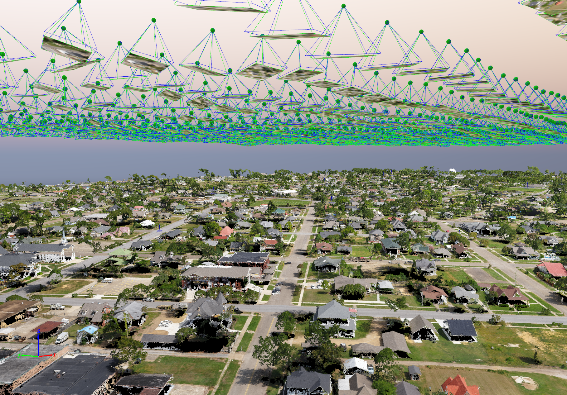
This is an image taken from the software Pix4D that we used to process the imagery collected with our AgEagle eBee X.
3248 Total Images
~700 Acres
How Does Photogrammetry Work?
Image Capture:
High-resolution cameras capture multiple overlapping photographs of the target area from different angles.
Drones are often used for aerial photogrammetry, providing a comprehensive view of large and inaccessible areas.
Processing:
Specialized software analyzes the images and identifies common points between them.
Using these points, the software reconstructs the geometry of the captured area, creating a detailed 3D model.
Output:
The final output can include orthophotos (geometrically corrected images), digital elevation models (DEMs), 3D point clouds, and more.
These outputs provide accurate measurements and detailed visualizations of the surveyed area.
Benefits of Photogrammetry for Your Projects
Precision and Accuracy:
Photogrammetry offers highly accurate measurements, which are crucial for planning and executing projects with precision. This level of detail helps prevent costly mistakes and ensures regulatory compliance.
Efficiency:
Traditional surveying methods can be time-consuming and labor-intensive. Photogrammetry, on the other hand, allows for rapid data collection over large areas, significantly reducing the time required to complete surveys.
Cost-Effective:
By reducing the time and manpower needed for surveys, photogrammetry can lower overall project costs. The ability to quickly identify and address potential issues can also save money in the long run.
Enhanced Visualization:
The detailed 3D models and high-resolution images produced by photogrammetry provide a clear and comprehensive view of the project area. This improved visualization aids in better planning, communication, and decision-making.
Versatility:
Photogrammetry can be applied to a wide range of projects, from mapping coastal erosion for water management to creating topographic surveys for real estate development. Its versatility makes it an invaluable tool for various industries.
Why Choose Seaside Engineering and Surveying LLC for Photogrammetry?
At Seaside Engineering and Surveying LLC, we leverage our extensive experience and state-of-the-art technology to deliver top-notch photogrammetry services. Here's why you should partner with us:
Expertise: Our team of skilled surveyors and engineers has the knowledge and experience to execute photogrammetry projects with precision and accuracy.
Innovation: We are committed to staying at the forefront of technology, ensuring that our clients benefit from the latest advancements in surveying techniques.
Customized Solutions: We understand that every project is unique. We tailor our photogrammetry services to meet the specific needs and goals of each client, ensuring optimal results.
Comprehensive Support: From initial consultation to project completion, we provide continuous support and guidance, ensuring a smooth and successful surveying process.
Conclusion
Photogrammetry is a powerful tool that can greatly enhance the accuracy, efficiency, and cost-effectiveness of your surveying projects. At Seaside Engineering and Surveying LLC, we are dedicated to providing innovative and reliable surveying solutions to help you achieve your project goals. Contact us today to learn more about how our photogrammetry services can benefit your next project.